Dear Volunteers,
Grampus Heritage is delighted to invite you to join our exciting new community archaeology project. Dust off your thermals and grab a flask because this time we are ‘going to the wall’!
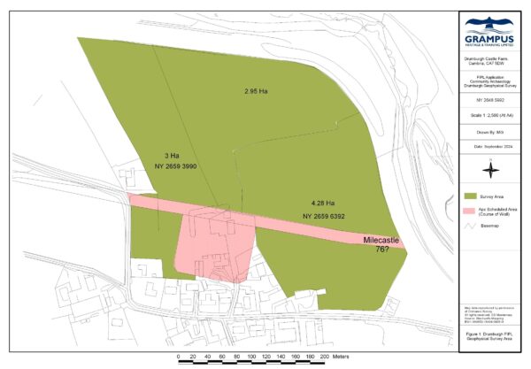
Funded by Defra through Solway Coast National Landscape’s Farming in Protected Landscapes programme, we will undertake a geophysical survey (resistance and magnetometry) on farmland at Drumburgh in Cumbria. The survey area (map image attached) sits within the Solway Coast National Landscape, within the Hadrian’s Wall World Heritage Site and includes a scheduled area covering the projected route of Hadrian’s Wall to the east of the fort, leading to the proposed location of milecastle 76. It is hard to imagine a more ‘protected landscape’, and yet, our survey can add greatly to our understanding of the archaeology in this area. The survey will cover the eastern extent of the scheduled area from the fort ‘Congavata’ to the proposed location of Milecastle 76. By covering the whole area highlighted, the survey is an exercise in prospection to identify archaeological remains from all periods.
We have a Section 42 license to enable our survey to cover the area of the scheduled monument. You can view the Historic England List Entry by clicking this link: https://historicengland.org.uk/listing/the-list/list-entry/1014699?section=official-list-entry
It can be tempting to think that such an iconic monument as Hadrian’s Wall is fully understood, but this is not always the case. The listing acknowledges that: “Drumburgh Roman fort, known to the Romans as Congavata, commanded an outlook to the north and east over the Inner Solway. There has been very little archaeological work carried out on this fort, and it remains one of the least well known Wall forts.”
The survey will aim to cover the whole fields highlighted, rather than just the scheduled monument. This is because we always aim to look at the bigger picture and we may well encounter features associated with pre or post-Roman activity. Once again, this is a landscape-level survey with high archaeological potential.
If you are able to join us for any of the days listed below please reply to Emma at: emmagrampusheritage@gmail.com
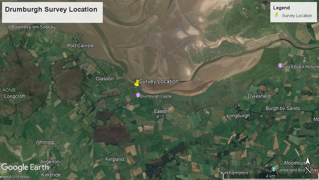
Survey Location: The Grange, Drumburgh, CA7 5DW
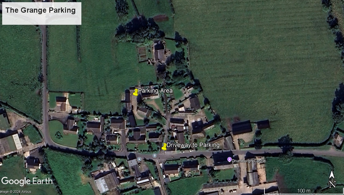
Please note that the survey is based at The Grange with parking available in the yard. The Grange is located on the opposite side of the road to the castle (north side of the road) and accessed by a driveway from the main road through the village (images attached).
Previous Survey’s Dates:
2024: Monday 25-30 November / Monday 2-4 December / Monday 9-14 December / Monday 16-19 December
2025: Monday 6-11 January / 13-18 January / 6- 25 October 2025
Results from previous survey’s:
Report on Archaeological Excavations at Drumburgh Castle Farm (March 2026)
Drumburgh, Wigton, Cumbria, CA7 5DW
NY 2656,5992
Geophysics report (March 2025)
Forthcoming excavation:
Dear Volunteers,
We are delighted to invite you to take part in an exciting archaeological excavation taking place at Drumburgh from 26th October to 14th November 2026 (excluding Sundays).
The project is funded by Defra through Solway Coast National Landscape’s Farming in Protected Landscapes programme and is a great opportunity for us all to increase our understanding of the UNESCO designated Hadrian’s Wall World Heritage Site at Drumburgh. This fieldwork will build on the results of our previous research at Drumburgh Castle Farm and we have applied for scheduled monument consent (SMC) to excavate two trenches within the scheduled area. The outcome of our SMC application will determine the precise location of our trenches but we have exciting targets to investigate both within and outside of the scheduled area. We are confident that this excavation will greatly enhance our understanding of the Roman archaeology and fort of Congavata at Drumburgh.
Volunteering
Working hours for volunteers are from 09:30 – 16:00 each day. Days may be cancelled or cut-short in the event of extreme weather.
Please bring your own lunch, waterproof clothing and wear sturdy boots for excavation. Tools, equipment and training will be provided and no previous experience is necessary to participate.
Google Earth images are attached to show the location of Drumburgh and the parking area at: The Grange, Drumburgh, CA7 5DW. To access the Grange, enter the village of Drumburgh and take the turning opposite the signposted turn to the RSPB reserve. Follow the track around to the left to enter the parking area.
Toilet facilities and a covered area for lunch break are available at the Grange. We are extremely grateful to Sarah Hodgson and family for making these facilities available.
Parking Location what3words: crumbles.quicker.even
We aim to work with 10 volunteers per day throughout the excavation and to give as many people as possible the chance to participate. We would particularly like to encourage volunteers from Drumburgh and the surrounding area so please feel free to share this email with anybody who may be interested.
Excavation dates are
Week 1: 26th to 31st October
Week 2: 2nd to 7th November
Week 3: 9th to 14th November
To register please email to: emmagrampusheritage@gmail.com
WSI document (Written Scheme of Investigation for Archaeological Evaluation at Drumburgh Castle Farm)
Please find the parking area displayed on the image below: