
Any available placements will show above. Click on the available placement information for more details.
Accommodation: shared rooms, possibly mixed with other university students
Meals: food is provided to participants by a third party. Participants pay for their food direct to the caterers though money provided by Grampus
Communication: internet available at accommodation
Transport: walk to site, public transport
Flights: participants will fly from London Stanstead airport. Participants have to fund their own travel to UK airports
Weather: usually hot and dry, can get up to 35 degree C
GHIC: Students must apply for a Global Health Insurance Card before the placement, and carry it on them at all times
The placement will be hosted by Masarykova University and the excavation will be Rokštejn castle.
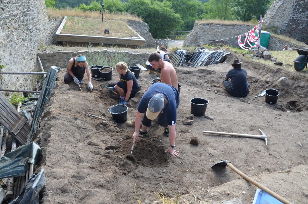
Work and free time
The group will be joining the team during working hours of 0730 – 1600. For anyone interested, the host team will be working after this doing post excavation work (finds washing, recording etc), which participants are invited to join if they wish to. Accommodation is in a house about 20 minutes walk away and the group will be working alongside the universities students. The group will be based in Panská Lhota, which has a little shop, or the nearest big town is Brtnice Town, a 10 minutes drive away and the nearest city is Jihlava is 30 minutes on the bus. There is an Aquapark in Jihlava and the area is full of castel ruins, deserted villages and other interesting historical sites. The group will arrive in Brno airport, which currently only has flights from London, and will get a train to Dolní Smrčné, which is a 20 minute walk to the accommodation.
Background to site
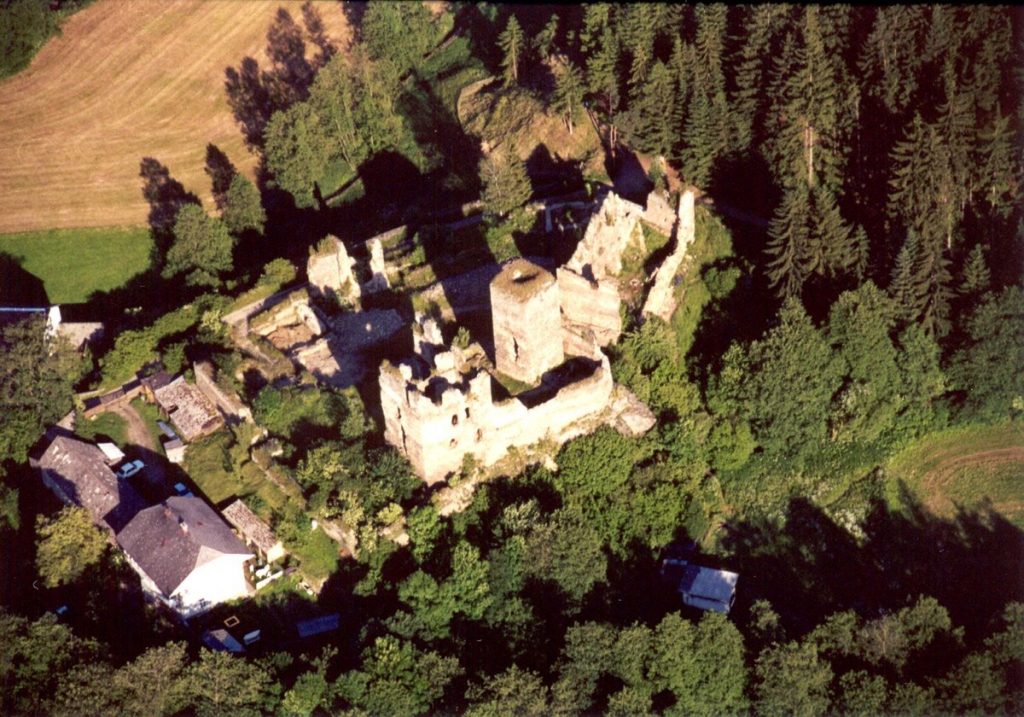
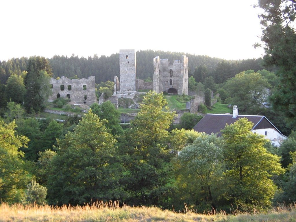
The remains of a stone castle stretch over a rocky spur on the left bank of the Brtnice river. From the Pavlice hill in the north the spur juts out into the wide canyon-like valley. The castle takes up the most part of plot 718 in the Brtnice – Panská Lhota cadastral area. It is a cultural heritage monument.
Within the Bohemian-Moravian Highlands, the microgegion with the Rokštejn castle site belongs to the Brtnická Uplands. The uplands consist of continual ridges separated by longitudinal depressions with a north-south orientation in the northern part of the uplands. The average elevation reaches 578.4 m above sea level and the highest point is the Špičák ridge which is 733 m above sea level. The flat Brtnická Uplands are made up of crystalline slate of the Moldanubicum with deep volcanic rocks of the central Moldanubic pluton and the Třebíč Massif. The Puklice Hills have a blanket of spruce trees with larch and pine, more rarely beech, and the landscape is interspersed with fields, meadows, and small ponds lined by marshes. The situation of the Zašovický ridge is similar, dominated by spruce trees, with rare beech stands, as well as fields and wet meadows. Rock outcrops exhibiting cryogenic phenomena rise above the surface of the bare plain. The river network forms a grid. The area belongs to the beech vegetation grade which is the most widespread grade in the Czech Republic, taking up 36% of the whole territory. It is found in uplands and highlands in elevations between 400-700 m above sea level. The moderately warm and mildly wet climate of the sub-oceanic type is characterised by an average annual temperature of 7°C and average precipitation of 700 mm. The Brtnice region belongs to moderately warm districts with higher precipitation. Lower annual temperatures reach only 6.5°C, while the total precipitation in the 1901-1950 period was relatively high, 600-700 mm, followed by a marked drop in the 1990s (Demek–Mackovčin–Balatka 2006, 18, 86, 256, 368, 515; Měřínský 2007, 6).
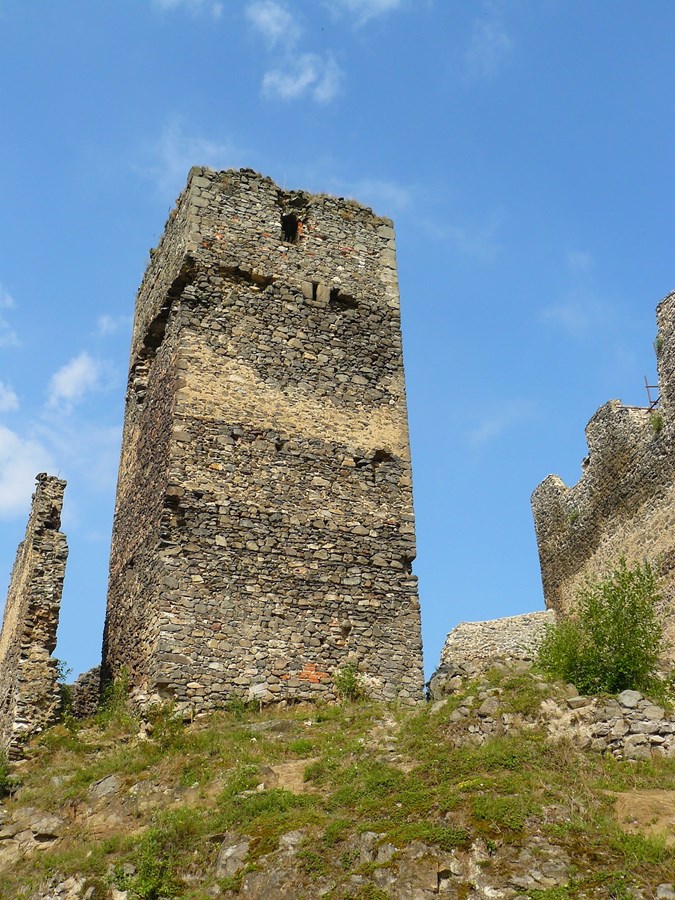
The existing castle remains: Rokštejn castle is a torsal heritage monument, a castle ruin. The surviving walls can be categorised as those belonging to the last phase of the castle’s existence and subjected to destruction, and walls recently exposed by excavation. As part of the castle rehabilitation work they were reinforced and arrangements were made for their public presentation. The precinct of Rokštejn castle is subdivided into Upper Castle, Lower Castle, north bailey, west, south and east outer wards.
The present state allows us to see the top view including the unearthed contexts from the past excavations carried out between 1958 and 1965, and since 1981.
Upper castle: The upper castle precinct is demarcated by the curtain wall and the building of the upper palace. The existing wall is interrupted on the eastern side by the gatehouse. The subtle square tower in the southern section was built in 1306/1307. The tower and the wall are separated by a narrow passage. The so-called upper palace adjoins the existing wall. The curtain wall of the upper castle is captured in two construction phases, an earlier one from the last third of the 13th century and the later one from the beginning of the 14th century. The recently reconstructed substructions of the walls of the structures east of the square tower which interrupted the old curtain wall from the 13th century are improvements from the first two thirds of the 15th century.
Lower castle: The precinct of the lower castle includes the building of the lower palace in the south-west corner while the western wall of the palace is simultaneously the wall of the lower castle. The curtain wall of the lower castle is interrupted only by the subtle square tower in the eastern section of the castle. The south and south-east section of the curtain wall is adjoined by so-called agricultural facilities marked with the letters A-F. The building of the castle blacksmith’s workshop was situated north of the eastern tower and was separated from the so-called building C by a narrow passage which served as a waste channel. Building C is tucked into the north-east corner. In the northern section the curtain wall is interrupted by a gatehouse which connects the north bailey with the courtyard of the lower castle.
North bailey: The area of the north bailey has been considerably disrupted by the construction of subrecent and recent structures connected with the operation of a paper mill and later water mill using water from the mill-race which had been dug around the western to north-eastern section of the castle’s perimeter. The new buildings in the north bailey stand with their northern wall on the original perimeter wall of the bailey. The original gateway to the bailey probably led through the north-east corner of the reconstructed perimeter wall of the bailey.
The west, south and east outer ward: this relatively narrow space was not suitable for economic activities. Rare sections of the outer ward rampart have survived to this day. The eastern section near building C was relatively easily accessed from the bailey and the area was walkable. The western section built below a rock outcrop was accessible only after terrain modifications and the rampart walkway was accessed via a small bridge from an exit gate in the lower castle situated between the lower palace and the rock outcrop of the upper castle; the southern section of the outer ward was the narrowest, as it copied the modified relief of the terrain from the earlier phases of the castle, behind the south outer ward rampart the castle was delimited by a deep depression of the slope which then rises towards the Pavlice hill.
Funding
This project has been funded with support from the Turing scheme, funded by the UK government. However our last Turing project ended in August 2024 and due to a change of eligibility criteria we are no longer allowed to apply for Turing funding.
This publication [communication] reflects the views only of the author, and Turing cannot be held responsible for any use which may be made of the information contained therein.